| In the midst of a metropolis
|
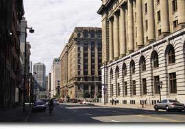
The width of Rue McGill at the western end of Place d'Youville can be traced back to the Commissioners' early 19th-century plan: when the fortifications were demolished, a vast passage was opened between the old town and the Faubourg des Récollets and would become one of Montréal's most prestigious streets. |
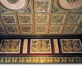
The headquarters of the Grand Trunk Railway Company (1900) and the ten-storey skyscraper belonging to Canadian Express (1907), its subsidiary, were indicative of the optimism reigning at the dawn of the 20th century. The Grand Trunk, already proud of its Victoria Bridge, was preparing to build a transcontinental railway line. It's definitely worth looking inside, if the building is open (today it houses government departments). The majolica bas-reliefs in the vestibule (glazed earthenware typical of the Italian Renaissance) and its open staircase won it plaudits as one of the most beautiful lobbies in Canada.
|
A new Custom House, with its fine colonnades, was opened in 1915 and expanded 20 years later, confirming Montréal's status as the gateway to the nation.
18th-century hospital, |