 |
|
|
Discovery
Tour of Old Montréal’s
Archaeological Sites |
|
|
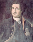
| Gaspard-Joseph
Chaussegros de Léry, born in Toulon in 1682,
was the King’s chief engineer in New France from
1716 to 1756. During this time, he planned and supervised
work on several defense systems in Montréal,
Québec City, Fort Chambly, Fort Niagara, Fort
Saint-Frédéric and Sault-Saint-Louis (Kahnawake).
Today, the spirit of Chaussegros de Léry beckons
us to discover these historic places by following these
marks on the ground, the archaeological reminders of
a bygone era. |
|
|
|
Did
You Know
That Montréal
Was a Fortified
City? |
|
|
Chaussegros de Léry
|
|
|
|
|
| When it was first founded,Montréal
was defended by fortified structures. As early as 1688, the colonial
administration urged its inhabitants to build a large number of
small forts,houses, fortified mills and redoubts—outworks
or fieldworks without flanking defences.The first stockade,made
of wood,was erected between 1687 and 1689. Louis XIV gave his
consent to build a stone fortification in 1712, and construction
began in 1716.
The new stone ramparts, built between 1717 and
1738, were a symbol of authority and a guarantee of security,
which both had a positive impact on the economy of Montréal.
In 1744, as war loomed, improvements were made. The ramparts were
designed according to the rules of fortification, the construction
art that takes the topography of the site into account. Since
Montréal is situated on relatively flat land, it was easy
to apply the principle of flanking, which requires that all parts
of the fortified wall be in the defenders’ full view.This
strategy was intended to protect the city from the greatest threat
to its security: a standard siege from a large military troop
pulling small artillery.
|
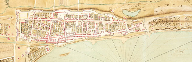
| Map of the City
of Montréal, September 10, 1725 by Chaussegros de Léry. Archives nationales (France), no 475B |
|
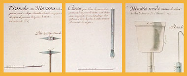
Tools
used for stonework. Anonymous,
circa 1740. Archives nationales du Québec
|
|
| A stonemasonry wall was
built on the side facing the St-Laurent River, where only attacks
by boat were possible. This wall was mounted with a parapet, pierced
with meurtrières, or gun sites, and, in some places,
was reinforced by a supporting wall and a terreplein, or sloping
bank.
A wall similar to the one facing the St-Laurent
was built on the land side to protect the enclosure from small
cannon fire.This wall was reinforced with a banquette—a
step running along the inside of the parapet and supporting the
wall-walk. A ditch and a glacis, or forward slope,were also planned
and together, they formed a defensive barrier over 25 metres wide.
Many types of craftsmen were recruited: the most
important were stonemasons and stonefitters, but haulers, carpenters,
blacksmiths, sawyers, locksmiths, roofers and other craftsmen
also lent their specialized skills to the site. However,most of
the workers were labourers, hired by building contractors and
construction supervisors to work alongside soldiers.
The 18th-century fortified city formed a dense
urban mosaic, dotted with large buildings—many belonging
to religious communities—landscaped with great walled gardens,
and nearly 400 houses were built during this time of expansion.
The fortifications were gradually dismantled between 1804 and
1817 following the adoption of The Act to Demolish the Old
Walls and Fortifications Surrounding the City of Montréal
in 1801.
Free from its enclosure walls, the city and its
suburbs now opened directly onto the river. This soon changed
the very pattern of the city, and as early as 1805, twice as many
people were living in the suburbs as in the city.
|
 |
|