
|
The fortifications...
|
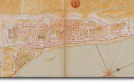
Can you imagine it? Although only the base of the stone walls remains now, they once stood up to 6.4 metres high and stretched for more than three kilometres around the town. It took more than 20 years, starting in 1717, to erect this double line of defence, designed by Gaspard Chaussegros de Léry, the King's Engineer in New France. At the time, all major French cities were fortified, and Montréal, as a trading post and military base of vital strategic importance in the struggle with the British, was certainly worth protecting! The inner wall was part of the scarp, and the outer wall formed the counterscarp. The ditch between the two walls was most likely poorly drained, as archaeologists have found bones of frogs, tree frogs, muskrats and turtles there.. The fortifications also included parapet-walks, loopholes to shoot through, posterns (small hidden doors), ramparts and glacis (earthen slope), as well as the town gates. |
| Home | Site map | Contact us |
Credits. All rights reserved, 1998-2001.
|