|
... the New Marketplace,
and a public square
The New Marketplace...
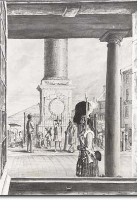
The Château came down and the New Marketplace went up. Covered wooden stalls sprang up in the centre, surrounded by stone buildings housing inns, stores and workshops.

View from the main city guardhouse (1845), artist unknown; the market stalls are visible behind the Nelson Column.
An Amerindian trail, then a "castle"...
After 1850...
Place Jacques-Cartier |
... and, lastly, a public square
When the Bonsecours Market opened for business in 1847, the "old" New Marketplace was demolished and turned into Place Jacques-Cartier. Market gardeners and craftspeople continued to offer their wares as an outdoor extension of the New Marketplace, however.
Built during the same period, these houses mark changes in architectural styles after 1800, notably the use of cut stone façades. |

